
Young Researcher Paper Award 2025
🥇Winners
🥇Winners
Print: ISSN 0914-4935
Online: ISSN 2435-0869
Sensors and Materials
is an international peer-reviewed open access journal to provide a forum for researchers working in multidisciplinary fields of sensing technology.
Online: ISSN 2435-0869
Sensors and Materials
is an international peer-reviewed open access journal to provide a forum for researchers working in multidisciplinary fields of sensing technology.
Tweets by Journal_SandM
Sensors and Materials
is covered by Science Citation Index Expanded (Clarivate Analytics), Scopus (Elsevier), and other databases.
Instructions to authors
English 日本語
Instructions for manuscript preparation
English 日本語
Template
English
Publisher
MYU K.K.
Sensors and Materials
1-23-3-303 Sendagi,
Bunkyo-ku, Tokyo 113-0022, Japan
Tel: 81-3-3827-8549
Fax: 81-3-3827-8547
MYU Research, a scientific publisher, seeks a native English-speaking proofreader with a scientific background. B.Sc. or higher degree is desirable. In-office position; work hours negotiable. Call 03-3827-8549 for further information.

MYU Research
(proofreading and recording)

MYU K.K.
(translation service)
The Art of Writing Scientific Papers
(How to write scientific papers)
(Japanese Only)
is covered by Science Citation Index Expanded (Clarivate Analytics), Scopus (Elsevier), and other databases.
Instructions to authors
English 日本語
Instructions for manuscript preparation
English 日本語
Template
English
Publisher
MYU K.K.
Sensors and Materials
1-23-3-303 Sendagi,
Bunkyo-ku, Tokyo 113-0022, Japan
Tel: 81-3-3827-8549
Fax: 81-3-3827-8547
MYU Research, a scientific publisher, seeks a native English-speaking proofreader with a scientific background. B.Sc. or higher degree is desirable. In-office position; work hours negotiable. Call 03-3827-8549 for further information.
MYU Research
(proofreading and recording)
MYU K.K.
(translation service)
The Art of Writing Scientific Papers
(How to write scientific papers)
(Japanese Only)
Sensors and Materials, Volume 37, Number 4(2) (2025)
Copyright(C) MYU K.K.
Copyright(C) MYU K.K.
|
pp. 1423-1447
S&M3996 Research Paper of Special Issue https://doi.org/10.18494/SAM5299 Published: April 18, 2025 Geospatial Monitoring of Urban Dynamics and Urbanization Impacts on Urban Green Landscape in Megacity Beijing Using the National Polar-orbiting Partnership Visible Infrared Imaging Radiometer Suite (NPP-VIIRS) Nighttime Light Data and Landsat Imagery (1999–2021) [PDF] Yanan Liu, MengXue Xu, Renjie Li, Ai Zhang, and Peng Gao (Received August 9, 2024; Accepted March 31, 2025) Keywords: urbanization, urban green, urban expansion, spatial comparison method, landscape pattern
Urbanization can lead to social and economic progress, but it also inevitably poses a threat to the urban environment and ecological systems, especially in a fast-growing metropolis. Quantifying spatiotemporal patterns of urban expansion and its impact can help optimize land use patterns and promote sustainable urban development. In this study, we propose a novel methodological framework that (1) incorporates a spatial statistics approach for extracting built-up areas and a comprehensive evaluation method for assessing landscape changes, from overall trends to detailed internal dynamics, and (2) aims to quantify urban dynamics and investigate their impacts on urban green spaces. The time-series National Polar-orbiting Partnership Visible Infrared Imaging Radiometer Suites (NPP-VIIRS) imagery and statistical data including geographic information system (GIS)-based analysis were used to calculate overall changes in urban land expansion speed and movement direction, respectively. The spatiotemporal characteristics of urban green landscape patterns (i.e., landscape-level and class-level metrics) were monitored with time-series Landsat images. The results indicate that urban areas have experienced rapid expansion, and the built-up area increased by 1008.75 km2 in the past 20 years. The urban expansion indices - including the expansion rate, intensity, and changes in urban migration center of gravity - reveal a distinct spatial structure of urban growth. This pattern was marked by both leapfrog development and the contiguous expansion of existing urban areas. Between 1999 and 2021, the gravity center of urban land consistently shifted in various directions. The area of built-up land decreased by −1.86% from 2014 to 2021, resulting in negative growth. Urban expansion has significantly altered the landscape pattern of urban green spaces, leading to the increased degree of fragmentation of built-up lands and a reduction in landscape diversity. Overall, geospatial monitoring is crucial in understanding how urban expansion affects urban green spaces and can provide more balanced and informed decision-making in urban growth.
Corresponding author: Yanan Liu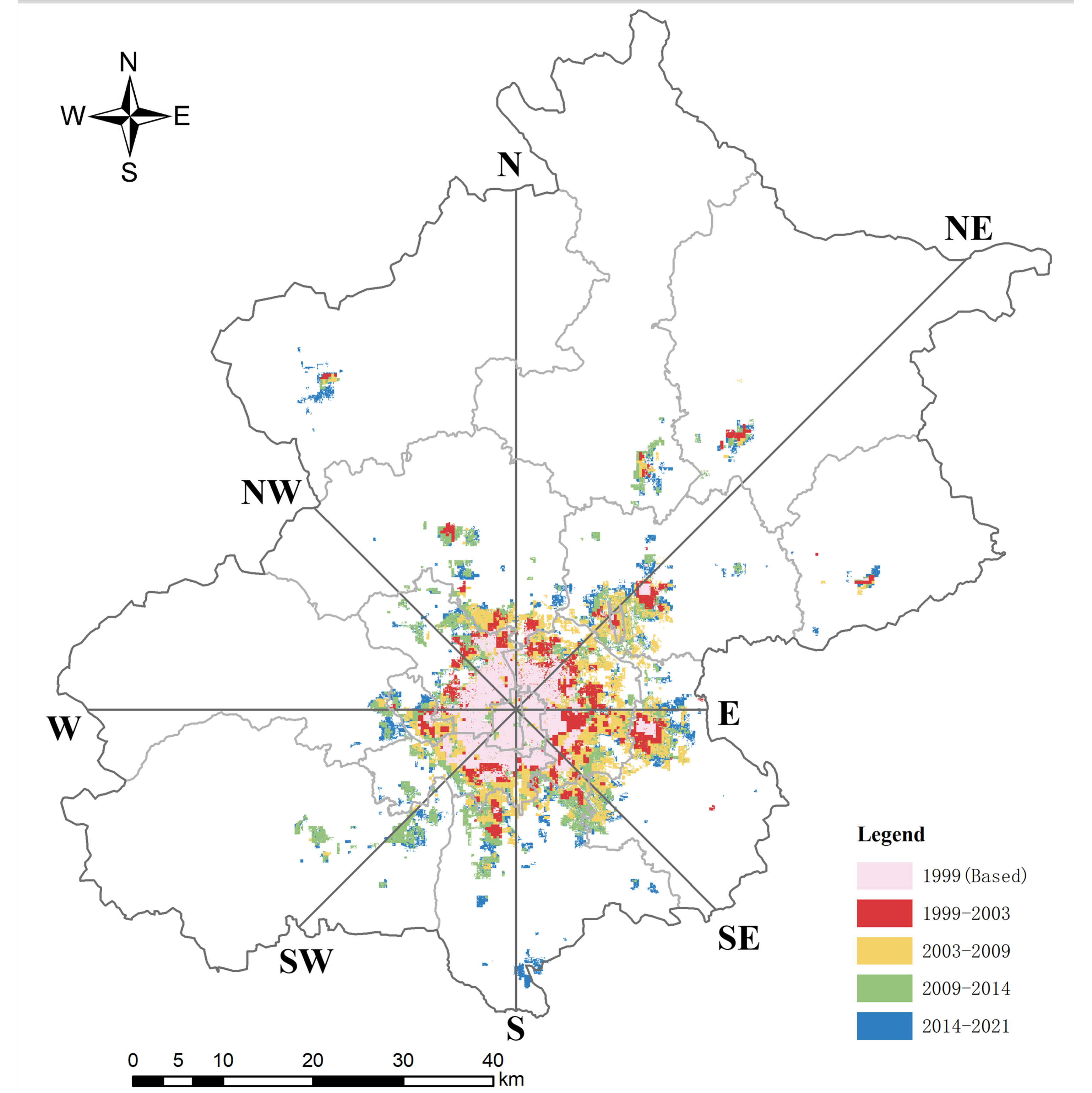  This work is licensed under a Creative Commons Attribution 4.0 International License. Cite this article Yanan Liu, MengXue Xu, Renjie Li, Ai Zhang, and Peng Gao, Geospatial Monitoring of Urban Dynamics and Urbanization Impacts on Urban Green Landscape in Megacity Beijing Using the National Polar-orbiting Partnership Visible Infrared Imaging Radiometer Suite (NPP-VIIRS) Nighttime Light Data and Landsat Imagery (1999–2021), Sens. Mater., Vol. 37, No. 4, 2025, p. 1423-1447. |
Forthcoming Regular Issues
Forthcoming Special Issues
Special Issue on Signal Collection, Processing, and System Integration in Automation Applications 2026
Guest editor, Hsiung-Cheng Lin (National Chin-Yi University of Technology), Ming-Te Chen (National Chin-Yi University of Technology), and Chin-Yi Cheng (National Yunlin University of Science and Technology)
Call for paper
Special Issue on Advanced GeoAI for Smart Cities: Novel Data Modeling with Multi-source Sensor Data
Guest editor, Prof. Changfeng Jing (China University of Geosciences Beijing)
Call for paper
Special Issue on Advanced Sensor Application Development
Guest editor, Shih-Chen Shi (National Cheng Kung University) and Tao-Hsing Chen (National Kaohsiung University of Science and Technology)
Call for paper
Special Issue on Sensing Beyond Transduction: Materials, Devices, and Signal Processing for Intelligent Sensory Systems
Guest editor, Masayuki Sohgawa (Niigata University)
Call for paper
Special Issue on Advanced Materials and Technologies for Sensor and Artificial- Intelligence-of-Things Applications (Selected Papers from ICASI 2026)
Guest editor, Sheng-Joue Young (National Yunlin University of Science and Technology)
Conference website
Call for paper
Special Issue on Biosensing Devices
Guest editor, Kiyotaka Sasagawa (Nara Institute of Science and Technology)
Call for paper
-
For more information of Special Issues (click here)
-
Special Issue on Mobile Computing and Ubiquitous Networking for Smart Society
- Accepted papers (click here)
- High-precision Autonomous Driving Map Quality Inspection Indicator System and Evaluation Method
Chengcheng Li, Ming Dong, Hongli Li, Xunwen Yu, Yongxuan Liu, and Chong Zhang - Surface Albedo in Different Land Cover Types in Northeast China
Tao Pan, Fu Li, Yucheng Tao, Lijuan Zhang, and Xiaoyan Jiang
- High-precision Autonomous Driving Map Quality Inspection Indicator System and Evaluation Method
- Accepted papers (click here)
- Negative Temperature Coefficient Thermistor with Multilayer Thin-film Structure AlN/VOx/AlN on Si(100) Substrate
Chen-Hung Yen, Ing-Jiunn Su, and Hui-Huang Hsieh
- Negative Temperature Coefficient Thermistor with Multilayer Thin-film Structure AlN/VOx/AlN on Si(100) Substrate
Guest editor, Akira Uchiyama (The University of Osaka) and Jaehoon Paul Jeong (Sungkyunkwan University)
Call for paper
Special Issue on Novel Sensors, Materials, and Related Technologies on Artificial Intelligence of Things Applications
Guest editor, Teen-Hang Meen (National Formosa University), Wenbing Zhao (Cleveland State University), and Cheng-Fu Yang (National University of Kaohsiung)
Call for paper
Special Issue on Low-altitude Economy: Technologies, Infrastructure, and Applications
Guest editor, He Huang and Junxing Yang (Beijing University of Civil Engineering and Architecture)
Call for paper
Special Issue on Multisource Sensors for Geographic Spatiotemporal Analysis and Social Sensing Technology Part 5
Guest editor, Prof. Bogang Yang (Beijing Institute of Surveying and Mapping) and Prof. Xiang Lei Liu (Beijing University of Civil Engineering and Architecture)
Special Issue on Materials, Devices, Circuits, and Analytical Methods for Various Sensors (Selected Papers from ICSEVEN 2026)
Guest editor, Chien-Jung Huang (National University of Kaohsiung), Mu-Chun Wang (Minghsin University of Science and Technology), Shih-Hung Lin (Chung Shan Medical University), Ja-Hao Chen (Feng Chia University)
Conference website
Call for paper
Special Issue on Sensing and Data Analysis Technologies for Living Environment, Health Care, Production Management, and Engineering/Science Education Applications (2026)
Guest editor, Chien-Jung Huang (National University of Kaohsiung), Rey-Chue Hwang (I-Shou University), Ja-Hao Chen (Feng Chia University), Ba-Son Nguyen (University of Economics Ho Chi Minh City)
Call for paper
Special Issue on Spatial Intelligence, Digital Twins, and AI-driven Smart Systems for Next-Generation Built Environment
Guest editor, Jae Kang Lee (Dong-A University), Myeong Hun Jeong (Chosun University), and Dong Ha Lee (Kangwon National University),
Call for paper
Special Issue on Intelligent Sensing and AI-driven Optimization for Sustainable Smart Manufacturing
Guest editor, Cheng-Chi Wang (National Sun Yat-sen University)
Call for paper
- Accepted papers (click here)
Copyright(C) MYU K.K. All Rights Reserved.