
Young Researcher Paper Award 2025
🥇Winners
🥇Winners
Print: ISSN 0914-4935
Online: ISSN 2435-0869
Sensors and Materials
is an international peer-reviewed open access journal to provide a forum for researchers working in multidisciplinary fields of sensing technology.
Online: ISSN 2435-0869
Sensors and Materials
is an international peer-reviewed open access journal to provide a forum for researchers working in multidisciplinary fields of sensing technology.
Tweets by Journal_SandM
Sensors and Materials
is covered by Science Citation Index Expanded (Clarivate Analytics), Scopus (Elsevier), and other databases.
Instructions to authors
English 日本語
Instructions for manuscript preparation
English 日本語
Template
English
Publisher
MYU K.K.
Sensors and Materials
1-23-3-303 Sendagi,
Bunkyo-ku, Tokyo 113-0022, Japan
Tel: 81-3-3827-8549
Fax: 81-3-3827-8547
MYU Research, a scientific publisher, seeks a native English-speaking proofreader with a scientific background. B.Sc. or higher degree is desirable. In-office position; work hours negotiable. Call 03-3827-8549 for further information.

MYU Research
(proofreading and recording)

MYU K.K.
(translation service)
The Art of Writing Scientific Papers
(How to write scientific papers)
(Japanese Only)
is covered by Science Citation Index Expanded (Clarivate Analytics), Scopus (Elsevier), and other databases.
Instructions to authors
English 日本語
Instructions for manuscript preparation
English 日本語
Template
English
Publisher
MYU K.K.
Sensors and Materials
1-23-3-303 Sendagi,
Bunkyo-ku, Tokyo 113-0022, Japan
Tel: 81-3-3827-8549
Fax: 81-3-3827-8547
MYU Research, a scientific publisher, seeks a native English-speaking proofreader with a scientific background. B.Sc. or higher degree is desirable. In-office position; work hours negotiable. Call 03-3827-8549 for further information.
MYU Research
(proofreading and recording)
MYU K.K.
(translation service)
The Art of Writing Scientific Papers
(How to write scientific papers)
(Japanese Only)
Sensors and Materials, Volume 37, Number 9(2) (2025)
Copyright(C) MYU K.K.
Copyright(C) MYU K.K.
|
pp. 3975-4003
S&M4164 Research paper of Special Issue https://doi.org/10.18494/SAM5693 Published in advance: September 17, 2025 Published: September 26, 2025 Slope-adaptive Elliptical Neighborhood Algorithm for Denoising Photon-counting LiDAR Data in Complex Terrain [PDF] Kuifeng Luan, Lizhe Zhang, Weidong Zhu, Wei Kong, Lin Liu, Jinhui Zheng, Peiyao Zhang, Xiangrong Chen, and Hui Jiang (Received April 14, 2025; Accepted August 28, 2025) Keywords: ICESat-2 photon data, adaptive elliptical neighborhood, local terrain features, denoising, complex terrain
The Ice, Cloud, and Land Elevation Satellite-2 (ICESat-2), owing to its sensitive photon detection system, acquires data containing a large number of background noise photons, which seriously affects the accuracy of signal extraction in complex terrain regions. To address the problem of insufficient parameter adaptability in existing denoising algorithms for slope-varying regions, we propose a denoising algorithm for slope-adaptive elliptic neighborhoods (SAEN-D), which is based on local terrain features. First, the effective signal range is intercepted by histogram statistics, and more than 88.82% of the discrete noise is preprocessed and rejected using grid statistics. Then, an adaptive elliptic neighborhood with slope angle constraints is constructed by a slope-driven segmentation strategy, and the search direction and the length of the ellipse’s long-axis are dynamically adjusted to match the signal distribution characteristics. Finally, the combination of the local distance discrepancy coefficient and OTSU’s method (OTSU) of thresholding segmentation is used to accurately distinguish signal and noise photons. Experiments are carried out in the regions of Antarctica’s flat ice cap and Greenland’s complex terrain, and the results show that in extreme terrains such as that with steep slopes and elevation faults, the value of the method described in this paper reaches 96.13–98.25%, which is 7.8% higher than that of the traditional improved local sparse coefficient (ILSC) algorithm. The results of the study confirm that SAEN-D effectively solves the problem of signal leakage and misjudgment caused by the anisotropy of photon distribution in complex terrain, and provides reliable support for high-precision elevation inversion and the dynamic monitoring of ICESat-2 data. This algorithm has broad application potential, as it can significantly improve the quality of laser altimetry satellite data and offers new insights and solutions for precise monitoring using sensor technologies in complex and variable terrains.
Corresponding author: Lizhe Zhang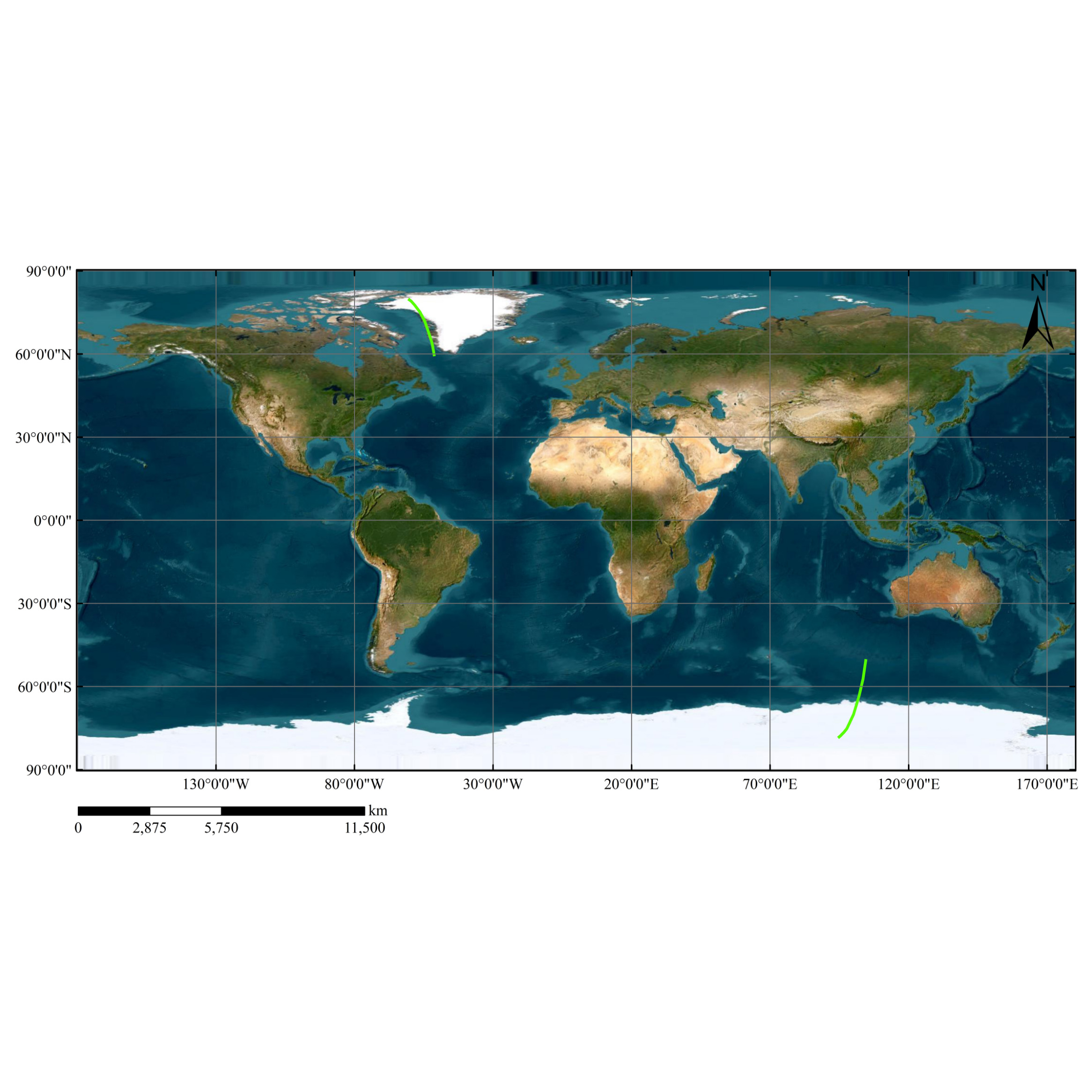  This work is licensed under a Creative Commons Attribution 4.0 International License. Cite this article Kuifeng Luan, Lizhe Zhang, Weidong Zhu, Wei Kong, Lin Liu, Jinhui Zheng, Peiyao Zhang, Xiangrong Chen, and Hui Jiang, Slope-adaptive Elliptical Neighborhood Algorithm for Denoising Photon-counting LiDAR Data in Complex Terrain, Sens. Mater., Vol. 37, No. 9, 2025, p. 3975-4003. |
Forthcoming Regular Issues
Forthcoming Special Issues
Special Issue on Signal Collection, Processing, and System Integration in Automation Applications 2026
Guest editor, Hsiung-Cheng Lin (National Chin-Yi University of Technology), Ming-Te Chen (National Chin-Yi University of Technology), and Chin-Yi Cheng (National Yunlin University of Science and Technology)
Call for paper
Special Issue on Advanced GeoAI for Smart Cities: Novel Data Modeling with Multi-source Sensor Data
Guest editor, Prof. Changfeng Jing (China University of Geosciences Beijing)
Call for paper
Special Issue on Advanced Sensor Application Development
Guest editor, Shih-Chen Shi (National Cheng Kung University) and Tao-Hsing Chen (National Kaohsiung University of Science and Technology)
Call for paper
Special Issue on Sensing Beyond Transduction: Materials, Devices, and Signal Processing for Intelligent Sensory Systems
Guest editor, Masayuki Sohgawa (Niigata University)
Call for paper
Special Issue on Advanced Materials and Technologies for Sensor and Artificial- Intelligence-of-Things Applications (Selected Papers from ICASI 2026)
Guest editor, Sheng-Joue Young (National Yunlin University of Science and Technology)
Conference website
Call for paper
Special Issue on Biosensing Devices
Guest editor, Kiyotaka Sasagawa (Nara Institute of Science and Technology)
Call for paper
-
For more information of Special Issues (click here)
-
Special Issue on Mobile Computing and Ubiquitous Networking for Smart Society
- Accepted papers (click here)
- High-precision Autonomous Driving Map Quality Inspection Indicator System and Evaluation Method
Chengcheng Li, Ming Dong, Hongli Li, Xunwen Yu, Yongxuan Liu, and Chong Zhang - Surface Albedo in Different Land Cover Types in Northeast China
Tao Pan, Fu Li, Yucheng Tao, Lijuan Zhang, and Xiaoyan Jiang
- High-precision Autonomous Driving Map Quality Inspection Indicator System and Evaluation Method
- Accepted papers (click here)
- Negative Temperature Coefficient Thermistor with Multilayer Thin-film Structure AlN/VOx/AlN on Si(100) Substrate
Chen-Hung Yen, Ing-Jiunn Su, and Hui-Huang Hsieh
- Negative Temperature Coefficient Thermistor with Multilayer Thin-film Structure AlN/VOx/AlN on Si(100) Substrate
Guest editor, Akira Uchiyama (The University of Osaka) and Jaehoon Paul Jeong (Sungkyunkwan University)
Call for paper
Special Issue on Novel Sensors, Materials, and Related Technologies on Artificial Intelligence of Things Applications
Guest editor, Teen-Hang Meen (National Formosa University), Wenbing Zhao (Cleveland State University), and Cheng-Fu Yang (National University of Kaohsiung)
Call for paper
Special Issue on Low-altitude Economy: Technologies, Infrastructure, and Applications
Guest editor, He Huang and Junxing Yang (Beijing University of Civil Engineering and Architecture)
Call for paper
Special Issue on Multisource Sensors for Geographic Spatiotemporal Analysis and Social Sensing Technology Part 5
Guest editor, Prof. Bogang Yang (Beijing Institute of Surveying and Mapping) and Prof. Xiang Lei Liu (Beijing University of Civil Engineering and Architecture)
Special Issue on Materials, Devices, Circuits, and Analytical Methods for Various Sensors (Selected Papers from ICSEVEN 2026)
Guest editor, Chien-Jung Huang (National University of Kaohsiung), Mu-Chun Wang (Minghsin University of Science and Technology), Shih-Hung Lin (Chung Shan Medical University), Ja-Hao Chen (Feng Chia University)
Conference website
Call for paper
Special Issue on Sensing and Data Analysis Technologies for Living Environment, Health Care, Production Management, and Engineering/Science Education Applications (2026)
Guest editor, Chien-Jung Huang (National University of Kaohsiung), Rey-Chue Hwang (I-Shou University), Ja-Hao Chen (Feng Chia University), Ba-Son Nguyen (University of Economics Ho Chi Minh City)
Call for paper
Special Issue on Spatial Intelligence, Digital Twins, and AI-driven Smart Systems for Next-Generation Built Environment
Guest editor, Jae Kang Lee (Dong-A University), Myeong Hun Jeong (Chosun University), and Dong Ha Lee (Kangwon National University),
Call for paper
Special Issue on Intelligent Sensing and AI-driven Optimization for Sustainable Smart Manufacturing
Guest editor, Cheng-Chi Wang (National Sun Yat-sen University)
Call for paper
- Accepted papers (click here)
Copyright(C) MYU K.K. All Rights Reserved.